GULFPORT, MS. — Mike Hirshfield, the chief scientist aboard the ship Oceana Latitude, is a lean, white-bearded man with keen brown eyes. Currently, those eyes are trained on the Gulf of Mexico as he and a crew of 12 scientists conduct independent research on the impacts of the Deepwater Horizon oil spill.
“We’ve never had a circumstance where so much oil has come up from so deep,” he said during the launching party for the boat’s research mission to the gulf. “Nobody knows what we are going to find.”
During their mission, the Oceana crew is sampling and mapping subsurface oil, as well as using a remotely operated vehicle (ROV) to explore seafloor habitat areas as much as 3,200 feet below the surface that may have been harmed by underwater oil.
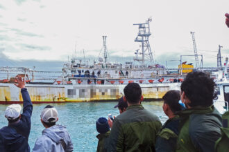
The Oceana crew isn’t the only one conducting independent research into the effects of the spill. Myriad academics, environmentalists and grassroots activists have been collecting data from water samples to video footage. And the environmental organization Greenpeace also has sent their 165-foot-long icebreaker, the Arctic Sunrise, on a three-month expedition to the area.
“Nobody is going to find it all out,” Hirshfield said. “All of us are trying to assemble a jigsaw puzzle, and we’re happy to contribute any piece we can.”
Many, from activists to fishermen, welcome independent research and are openly skeptical of official reports from both BP and the government.
“Since the spill first began we’ve been frustrated by the amount of spin on the scope of the spill and the impacts that it has caused,” said Greenpeace oceans campaign director John Hocevar, who is managing the Arctic Sunrise’s gulf research program.
“The most recent example of this troubling trend is the report that the National Incident Command put out last month – where basically they said its all fine, mission accomplished, we can go home, big success,” he added.
That scientific controversy hinged on a federal report that 75 percent of the spilled oil was gone. The results were widely questioned, and a subsequent independent report by the University of Georgia contended that 79 percent of the spilled oil remained in the ecosystem.
“One major misconception is that oil that has dissolved into water is gone and, therefore, harmless,” Charles Hopkinson, director of the Georgia Sea Grant and professor of marine sciences at the University of Georgia, said in a press release. “The oil is still out there, and it will likely take years to completely degrade. We are still far from a complete understanding of what its impacts are.”
And this is why the more eyes on the problem, the better, according to Hirshfield and Hocevar.
Three Dimensional Map
The Oceana Latitude is presently circling the site of the spill, where the crew has deployed hundreds of oil sensors designed to detect subsurface oil plumes.
The sensors are suspended from buoys that were placed along a series of transects surrounding the spill site. Each buoy dangles a cable, and the sensors are placed on that cable at 100-foot intervals so that they are likely to detect oil at any depth that it may occur. Beginning in the next few days, the sensors will be retrieved and sent to a laboratory for analysis.
“We hope to get a three-dimensional map,” Hirshfield said. “These little plastic strips are very sensitive.”
Other aspects of the Latitude’s mission are less rigorously scientific, Hirshfield notes.
“We’re not a university, and this isn’t a full-on research vessel,” he said while standing in the plushy white-carpeted, wood-paneled main room of the ship that was donated to the organization. “There was also the practical consideration of thinking of the kinds of things that we could put together quickly.”
Throughout their expedition, the Latitude crew will work in collaboration with several different universities and researchers in efforts to observe and tag a variety of shark species including tiger, hammerhead, and whale sharks, according to campaign manager Dustin Cranor.
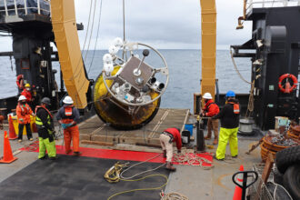
The third element of the organization’s mission depends on a small ROV device, which looks like an innocuous series of canisters inside a metal crate. This remotely operated machine is capable of reaching depths of over half a mile and filming high-definition footage. It is scheduled to explore a series of subsea hills and valleys where scientists fear that oil damages may have occurred.
“Even if we don’t see anything there, it doesn’t mean that nothing is going to happen,” Hirshfield said. “We could see delayed effects. Our data will be the baseline because we know people are going to be coming back.”
Concern over Methane
Meanwhile Greenpeace’s Arctic Sunrise has just begun a three-month stint in the Gulf of Mexico. The crew will act as support staff for a series of independent scientists from over a dozen universities, all of whom applied for the opportunity to work aboard the ship, Hocevar said.
Research projects include testing water quality, using a submarine to examine deep water coral, and using acoustic buoys to listen for endangered sperm whales.
At the moment, the Sunrise is docked in St. Petersburg, Florida, and preparing to start their own search for subsea oil plumes. The ship will lower a device from the ship to collect water samples that will be analyzed for the presence of both oil and methane.
“Part of the concern with methane is that the bacteria breaking down some of the oil use up a lot of oxygen,” Hocevar said. Since the gulf is already prone to large dead zones, the question is whether – and to what degree – the spill is contributing to that problem.
Over the last few weeks, the Sunrise crew has already helped scientists trawl for blue crab larvae and test delicate sea sponges for the presence of oil. But the immediate results of their research aren’t available yet, Hocevar said – and he’s okay with that.
“It’ll take laboratory analysis over the next few months to see what we found,” he said. “Part of our frustration with NOAA and the government is that it seems they’ve been too quick to imply that everything is okay.”
“It can take months and years to really figure out what the impacts are,” he added. “This is a very large and complex system.”
About This Story
Perhaps you noticed: This story, like all the news we publish, is free to read. That’s because Inside Climate News is a 501c3 nonprofit organization. We do not charge a subscription fee, lock our news behind a paywall, or clutter our website with ads. We make our news on climate and the environment freely available to you and anyone who wants it.
That’s not all. We also share our news for free with scores of other media organizations around the country. Many of them can’t afford to do environmental journalism of their own. We’ve built bureaus from coast to coast to report local stories, collaborate with local newsrooms and co-publish articles so that this vital work is shared as widely as possible.
Two of us launched ICN in 2007. Six years later we earned a Pulitzer Prize for National Reporting, and now we run the oldest and largest dedicated climate newsroom in the nation. We tell the story in all its complexity. We hold polluters accountable. We expose environmental injustice. We debunk misinformation. We scrutinize solutions and inspire action.
Donations from readers like you fund every aspect of what we do. If you don’t already, will you support our ongoing work, our reporting on the biggest crisis facing our planet, and help us reach even more readers in more places?
Please take a moment to make a tax-deductible donation. Every one of them makes a difference.
Thank you,