


Shelton Tucker is part of a novel plan to deal with the waters that are increasingly encroaching on his neighborhood in Hampton, Virginia.
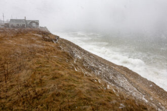
Situated at the mouth of the Chesapeake Bay and afflicted by one of the fastest paces of sea-level rise in the U.S., Hampton has long battled flooding.
But while flood-prone coastal cities have historically defaulted to levees, pumps and miles of cement-covered storm drains, Hampton is leaning heavily on rain barrels, rain gardens, declogging creeks and fortifying shores with oyster reefs.
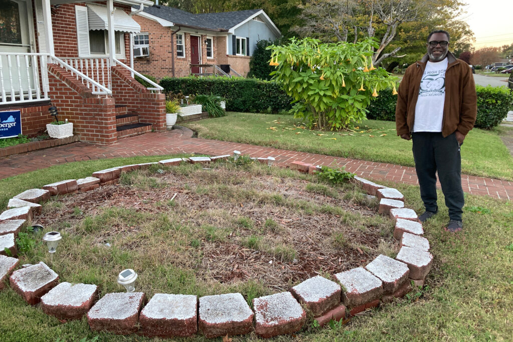
Hampton residents like Tucker have a part to play, too. The 67-year-old president of the Greater Aberdeen Community Coalition has a spot for a rain garden—a plot designed to collect and absorb stormwater runoff—prepared in the front yard of his father’s house.
“I got it all bricked out,” Tucker said. “I just need to know the plants to put in it.”
Living With Water
Hampton’s rain gardens and oyster reefs are part of a flood-management strategy heavily influenced by the Netherlands, dubbed “Living With Water.” At its core is a change in mindset about how to approach a future increasingly defined by rising oceans, more intense rains and soggier ground.
Instead of fighting water, the thinking goes, let it in. Guide it to areas where it can flow and sit safely; enjoy it while it’s there. Restore natural systems that absorb, buffer and cleanse. Take steps big and small, public and private, since every little bit counts.
In practice, that means Hampton is trying to better handle large volumes of water, dotting flood-prone areas with plant-lined storage basins, inserting low weirs in rivers to slow the flow of excess water and raising some key streets that are likely to submerge regardless.
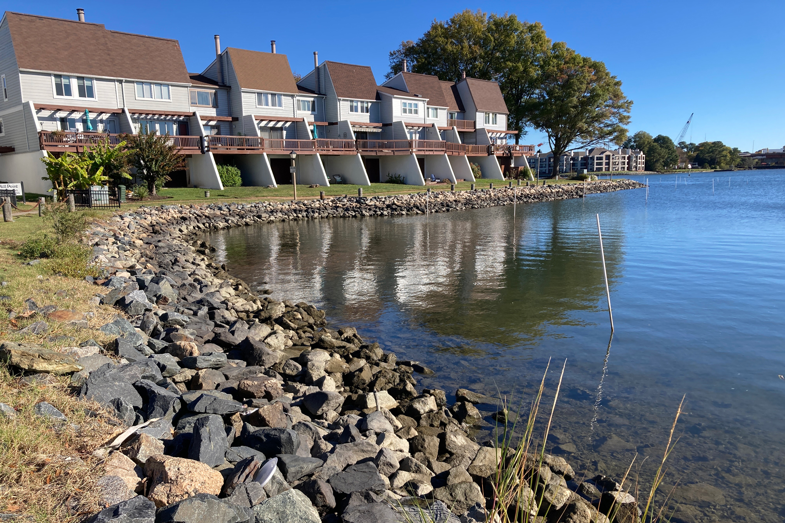
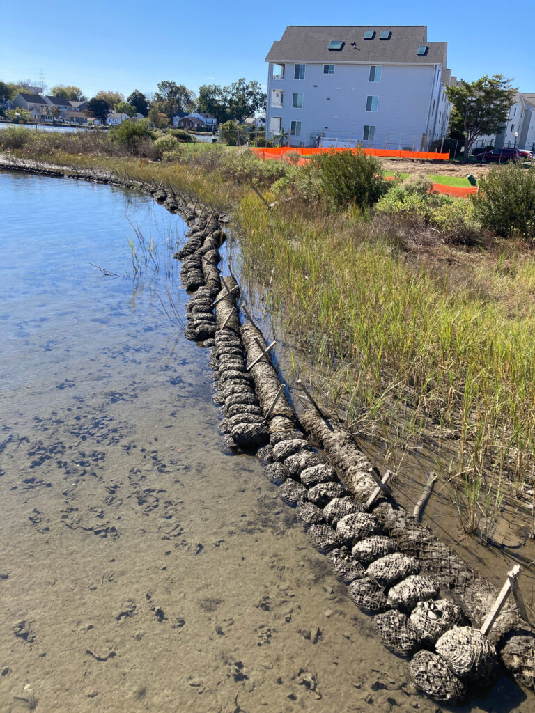
While some nearby coastal cities are proposing billion-dollar floodwalls and surge barriers, Hampton is looking at restoring marshes and “naturalizing” miles of rock-fortified shoreline with sand and marsh grasses.
At a coastal park a few blocks from Hampton City Hall, the city is building a sandy marsh over the rocks that currently line the shore, and experimenting with new types of protective sills—including 3D-printed concrete reefs seeded with oysters.
The changes mean incoming waves will be gently buffered, rather than reflected by hard surfaces as they are now, reducing flooding and erosion, said Olivia Askew, a Hampton city resilience officer.
The water “will rise and fall in the new marsh that we’re creating, which will soften the shoreline,” she said.
Learning to Adapt
Hampton’s history dates back to 1610, when a group of English colonists seized an Algonquin village and renamed it, making it the oldest continuously occupied English settlement in the U.S. Nine years later, Hampton was the landing site for some of the first African slaves to be transported to the country.

Langley Air Force Base was built in Hampton in 1917 and is still a major economic force in the area; NASA, the National Aeronautics and Space Administration, was born there.
Today, Hampton is a quiet city of 137,000. The lobby of City Hall hosts a towering decorated cake baked 40 years ago to celebrate Hampton’s 375th birthday, along with banners commemorating the five-time win, this year, of the National Civic League’s All-America City Award. The theme of that award-winning presentation was “Resilient Hampton.” It featured a video showing flooded streets, marshy shores and the line, “We can’t wall ourselves off from the water, but we can learn to adapt.”
Wealth Under Water
Hampton sits at the tip of a little peninsula where the James and York Rivers flow into the Chesapeake Bay, criss-crossed by scores of smaller tributaries, creeks and canals. It is in the center of the broader Hampton Roads estuary region, which forms one of the largest and deepest natural harbors in the world.
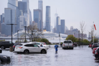
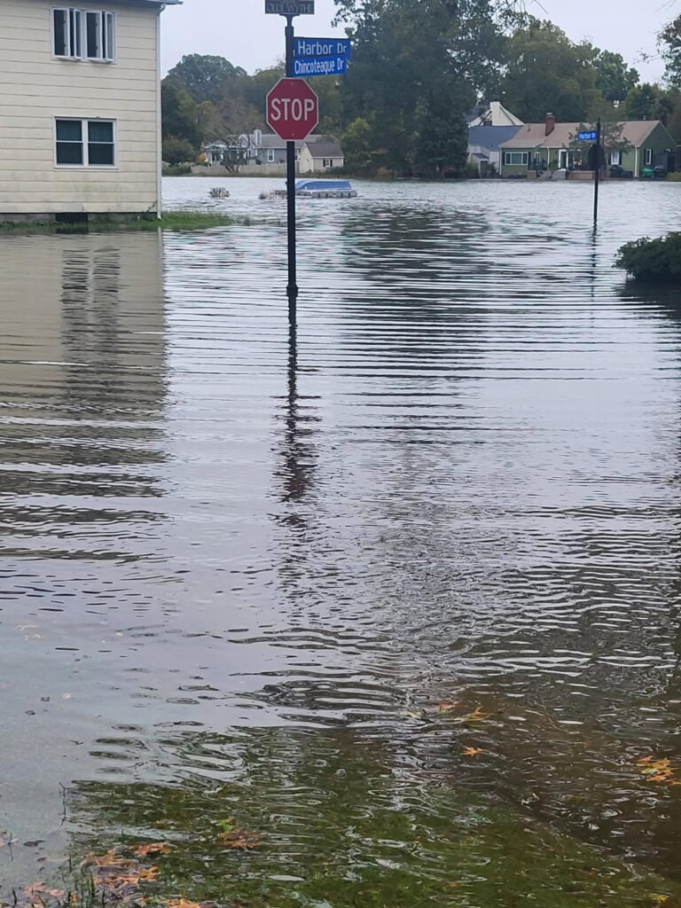
Between rising tides and sinking shores, Hampton Roads is experiencing one of the fastest changes in sea level in the U.S. The city of Hampton is planning for 1.5 feet of sea rise by 2040 and 4.5 feet by 2100, although another estimate puts the potential increase at 9.5 feet. Flooding in the city is exacerbated by winds that whip up waves and send them surging ashore, rivers and drains that back up and overflow during storms and soil that doesn’t drain well.
In the next 25 years or so, 39 miles of Hampton’s shoreline and almost 20 percent of its park land could be inundated, the city says. In 30 years, more than 80 percent of Hampton’s properties will be at risk of flooding, up from around 65 percent now, climate risk financial modeler First Street estimates.
Tucker, who grew up near the historic black neighborhood of Aberdeen Gardens in central Hampton, said he can already see changes in how water is affecting the area. Pools left after storms are taking much longer to dry, he said. Hazardous zones on flood maps are expanding; Tucker has his eye on one such zone across the street from his house, near a creek where he crabbed as a boy; one map showed that 30 years from now, a good portion of one of the neighborhoods in greater Aberdeen could be underwater.
Higher flood risk also means higher insurance rates. “There’s an economic factor to living in areas that are deemed to be unsafe,” said Tucker. “Like I told the community members here: ‘It’s essentially your wealth is going under water.'”
Learning From the Dutch
Despite the rising risks, Hampton didn’t have a comprehensive strategy to deal with all that incoming water until fairly recently, said Scott Smith, an avid rower and coastal resilience engineer, who worked for the neighboring city of Norfolk before moving to Hampton city government five years ago.
A decade ago, water management in the region was largely focused on water quality, he said. Cities in the area had flood-mitigation plans, and were starting to experience “sunny-day flooding,” where streets would regularly flood at high tide, even without a storm or heavy rain. But nobody talked about climate change or sea level rise, just “recurrent flooding,” he recalled.
Then in 2015, a New Orleans-based architect named David Waggonner brought some engineers from the Netherlands to the Hampton Roads area to discuss their approach to water. Waggonner had first reached out to Dutch experts after the devastating floods following Hurricane Katrina. Their insights, honed by centuries of experience with flooding, were so helpful that he started organizing similar workshops on Dutch-style solutions around the country.
“Building cities around water is the Dutch priority,” said Waggonner. “They would tell you that if they ignore the water system in the Netherlands, the country gets sick.”
The Dutch approach was adopted to various degrees by officials throughout the region, but it was particularly resonant in Hampton, said Mary-Carson Stiff, executive director of Wetlands Watch, a Norfolk-based nonprofit that worked with Tucker’s coalition and other community groups on resilience plans for the Aberdeen Gardens district.
Coastal flood management typically prioritizes big, expensive infrastructure projects like seawalls and levees. That requires not only a wall along the sea side, but more barriers along the back and sides, forming a kind of bathtub with the properties to be protected inside, along with pumps to remove water that comes in. “It’s a set: the bathtub and the pump,” said Smith.
That approach might make sense in a compact area with valuable assets to protect—although it also tends to prioritize defending million-dollar homes and businesses over cheaper real estate and lower-income neighborhoods.
But the city of Hampton, with its many intersecting streams and coastline along three sides, doesn’t have an “area to tie a wall into,” said Smith.
This story is funded by readers like you.
Our nonprofit newsroom provides award-winning climate coverage free of charge and advertising. We rely on donations from readers like you to keep going. Please donate now to support our work.
Donate NowHampton would also strain to fund the type of pricey infrastructure proposed by larger cities in Hampton Roads like Norfolk, which is spending $2.6 billion for a set of measures centered on storm-surge barriers and flood walls, or Virginia Beach, which in 2021 voted to spend more than $500 million on things like tide gates and pumps. Virginia Beach estimates the total cost of its flood-protection projects has risen to more than $1.5 billion.
“Different municipalities can take a different approach, depending on if they have the ability to do a $500 million referendum,” said Askew, the resilience officer. “The city of Hampton doesn’t have the financial capacity to do that. We look at a piecemeal approach to funding projects.”
No Silver Bullet
That piecemeal approach works well with the type of flood measures promoted by the Dutch engineers. Those feature multiple lines of defense, pockets of water storage and projects that serve more than one purpose, said Smith.
The Dutch city of Rotterdam, which declares on its website that “we no longer see water as a problem, but as an opportunity,” has an underground parking garage that doubles as water storage during storms. Many of Hampton’s water-management projects double as recreational spaces, like one that is converting a flood-prone drainage ditch into a cleaner, broader stream with a walking path alongside.
The Dutch approach also focused on green solutions that mimic nature whenever possible, and stressed the importance of taking lots of little steps to absorb or store water. In Hampton, those include encouraging residents like Tucker to install rain barrels and rain gardens or replace walls and rocks along miles of private coastline with sand, grasses and oyster reefs.
“There’s no silver bullet,” said Smith. “It’s multiple little things. The aggregation of multiple little things can make a difference.”
One example is the recently completed $2 million retrofit of Lake Hampton, previously a scraggly artificial storage basin behind a Home Depot, near a creek that regularly flooded during high tides and storms. The city cleaned up the shoreline, raised the berm on one side to let the lake store more water and installed tidal gates to stop cross-flooding with the creek. It also built a boardwalk and lakeside path, so residents could enjoy the scenery.
The retrofit has already reduced the amount of flooding in the area, and conditions should improve further once a nearby road is raised and water-absorbing bioswales are installed, said Anna Hammond, a city resilience specialist.
Water Means Risk
There are challenges for Hampton’s living-with-water approach.
Finding money—even for modest projects—is tough. In 2020, Hampton issued $12 million in bonds to finance the work around Lake Hampton as well as the drainage ditch retrofit—projects that are expected to add 8.6 million gallons of stormwater storage capacity and serve as models for future measures. But the Trump administration earlier this year cancelled a $20 million grant that was supposed to fund the rain gardens and retrofits at Aberdeen Gardens. The city and Wetlands Watch are looking for alternate sources of financing.
Evaluating the benefits of green infrastructure can be hard. It is easier for engineers to quantify the amount of protection a seawall would provide, versus, say, a stand of mangrove trees, said Smith. Walls take much less space than a nature-based feature that offers an equivalent level of shelter, he said. Ecological and social dividends tend to be ignored.
Bioswales, rain gardens and retrofitted creeks won’t ward off the massive amounts of water that can come from hurricanes or coastal flooding, said Smith. The city will likely still need some combination of hard, gray infrastructure and green, natural features, he said. As waters continue to rise with climate change, conditions for coastal cities will become more precarious.
“Water does mean risk,” said Wetlands Watch’s Stiff. “You’re welcoming the water in and you’re fully acknowledging that it is risky to do that.”
In Aberdeen Gardens, Tucker said the community doesn’t have much choice. “What is the alternative: not living with water?” he asked. “If you think that by not addressing the issue specifically that it will go away or it resolves, no it won’t. It’s inevitable. It’s just a matter of time.”
About This Story
Perhaps you noticed: This story, like all the news we publish, is free to read. That’s because Inside Climate News is a 501c3 nonprofit organization. We do not charge a subscription fee, lock our news behind a paywall, or clutter our website with ads. We make our news on climate and the environment freely available to you and anyone who wants it.
That’s not all. We also share our news for free with scores of other media organizations around the country. Many of them can’t afford to do environmental journalism of their own. We’ve built bureaus from coast to coast to report local stories, collaborate with local newsrooms and co-publish articles so that this vital work is shared as widely as possible.
Two of us launched ICN in 2007. Six years later we earned a Pulitzer Prize for National Reporting, and now we run the oldest and largest dedicated climate newsroom in the nation. We tell the story in all its complexity. We hold polluters accountable. We expose environmental injustice. We debunk misinformation. We scrutinize solutions and inspire action.
Donations from readers like you fund every aspect of what we do. If you don’t already, will you support our ongoing work, our reporting on the biggest crisis facing our planet, and help us reach even more readers in more places?
Please take a moment to make a tax-deductible donation. Every one of them makes a difference.
Thank you,