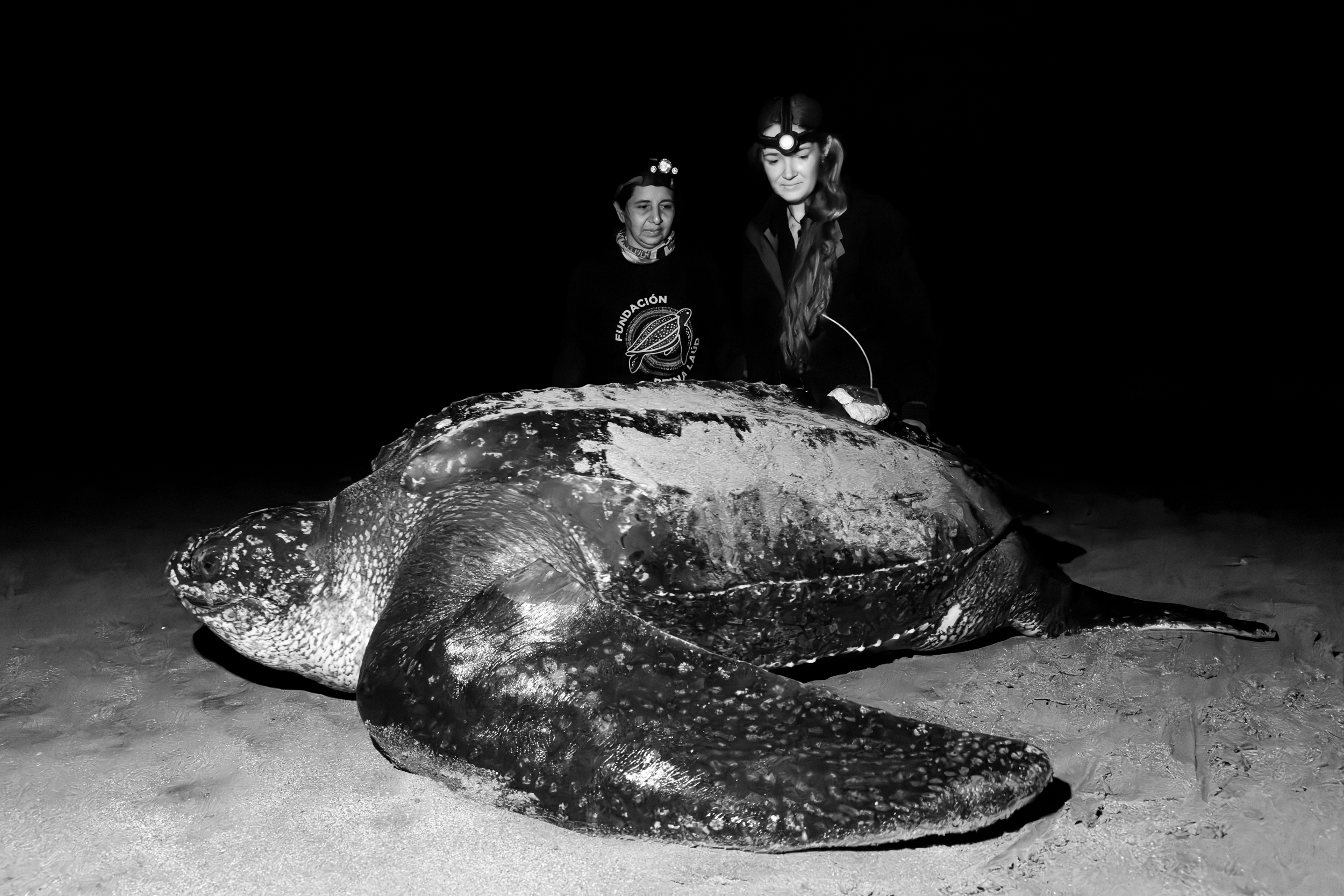


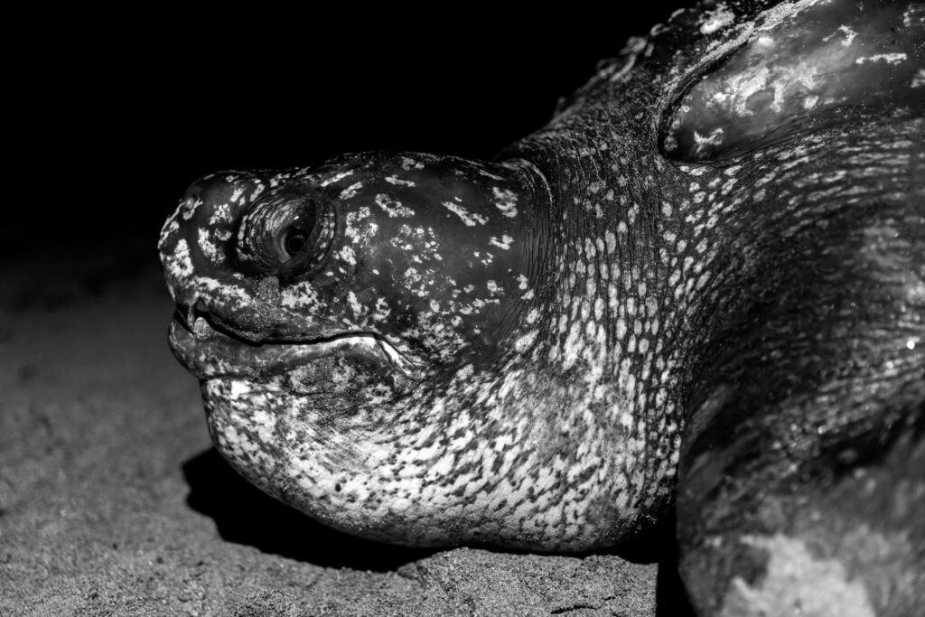
Just after 3 a.m. on a recent Friday morning, a 4.5-foot-long leatherback sea turtle covered her freshly dug nest with sand, sweeping and packing it into place with steady strokes of her flippers just above the high tide along a remote, rugged stretch of Ecuador’s Pacific coast.
Nearby, a team of scientists watched the turtle’s every movement, using brief pauses between her motions to carry out their own work: attaching an electronic tracking device, known as a satellite tag, to the animal’s leathery carapace.
“We just satellite-tagged the first leatherback sea turtle in all of Ecuador,” said Callie Veelenturf, a marine biologist from Massachusetts and co-founder of The Leatherback Project, a global sea turtle conservation nonprofit. Veelenturf co-led the tagging effort alongside Kerly Briones Cedeño, president and director general of Fundación Reina Laúd, a volunteer-run conservation group in Ecuador, which monitors sea turtle nesting habitat.
The milestone marks a new step toward better understanding one of the most endangered marine species in the world and the threats it faces. Eastern Pacific leatherbacks—a distinct population of the world’s largest sea turtle—have declined by more than 90 percent since the 1980s.
“There are likely less than 1,000 individuals left,” Veelenturf said.
Satellite tagging has long been used to study leatherbacks by tracking where they forage, mate and nest. But most of that work, Veelenturf said, has taken place in Mexico and Costa Rica, where the largest nesting populations have historically been concentrated. That’s left major gaps in understanding how the species uses waters farther south.
“We know very little about how they use coastal waters in the East Pacific and specifically in Ecuador,” Veelenturf said.
What is known, Veelenturf said, is that these endangered turtles face a gauntlet of threats off the Pacific coast, primarily posed by fishing activity.
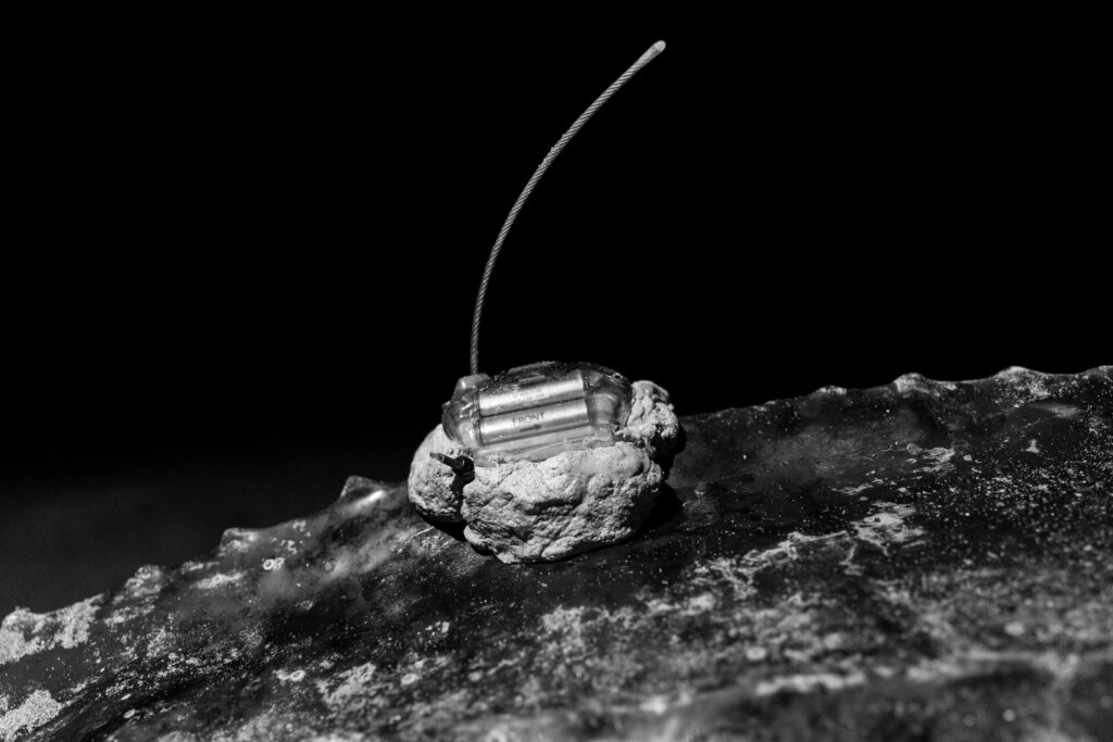
A newly attached satellite tag is attached to a leatherback sea turtle’s shell. This electronic tracking device is designed to transmit its location each time the turtle surfaces to breathe and record detailed dive data, helping scientists track its movements. Credit: Nikki Riddy
Ecuador hosts one of the largest artisanal fishing fleets in the eastern tropical Pacific, with tens of thousands of small-scale boats—typically fiberglass or wooden vessels operated by individual fishers. Large-mesh gillnets, widely used by these fleets, pose the greatest risk to sea turtles, which can become entangled in the gear and drown. Sharks, rays, whales, dolphins and seabirds are at risk too.
A 2020 study published in Scientific Reports by the Eastern Pacific Leatherback Conservation Network—also known as Red Laúd OPO—found Eastern Pacific leatherbacks could disappear by 2060 without concerted efforts to reduce their incidental capture in fishing gear.
In January, Briones Cedeño saw those impacts firsthand. While monitoring a known leatherback nesting beach, she encountered a dead female she recognized as one that had laid several nests earlier in the season.
“We were expecting her fifth nest,” she said. The turtle showed signs of asphyxiation from drowning, she said, likely caused by getting caught in fishing gear. “We presume that she died due to the issue of bycatch fisheries,” she said. “Perhaps if we had tagged her, we would have known she was passing nearby, or perhaps we could have rescued her.”
But preventing these types of deaths requires a clear picture of how leatherbacks move through Ecuador’s waters and the rest of the eastern tropical Pacific region, Veelenturf said.
“Understanding the overlap between artisanal, semi-industrial and industrial fishing activities with the leatherback habitat use is just so important,” she said. “If we don’t understand where they’re going and what their diving behavior is like, for example, we can’t really know how to best protect them.”
Satellite tagging offers one of the clearest ways to answer those questions.
By outfitting the turtle with a satellite tag that transmits its location each time it surfaces to breathe, researchers can now follow the animal in near real time through an online platform developed by Wildlife Computers, a company in Washington state that specializes in tracking marine life.
This story is funded by readers like you.
Our nonprofit newsroom provides award-winning climate coverage free of charge and advertising. We rely on donations from readers like you to keep going. Please donate now to support our work.
Donate NowThe tag Veelenturf’s team used, also created by that company, records detailed dive data, too, offering insight into not only how the turtle moves through coastal waters and the open ocean where leatherbacks spend most of their lives, but also how deep they swim.
Because leatherbacks can dive thousands of feet below the surface, protecting them not only requires knowing where they are, but also how their behavior may overlap with fishing gear set at different depths.
Over the past seven years, Veelenturf has led a long-term leatherback tagging program along the Atlantic coasts of Panama and Colombia, where her team fitted 24 nesting females with satellite transmitters. The resulting data has helped identify critical habitats, show migratory pathways and inform conservation strategies, particularly in areas where proposed coastal development projects, such as ports, may threaten the species.
Now, in Ecuador, Veelenturf hopes similar data can be used to pinpoint where turtles face the most risks and collaborate with local communities to mitigate them by altering fishing gear or establishing marine protected areas where certain human activities would be limited or prohibited.
Satellite tracking can help researchers focus those conservation efforts by identifying specific stretches of coastline or offshore waters where turtles are most vulnerable, as well as the times of year when risk is highest based on migration, nesting or mating patterns, said Bryan Wallace, a wildlife ecologist and co-coordinator of the Eastern Pacific Leatherback Turtle Conservation Network. That kind of precision can make conservation efforts more targeted and effective, he said.
But getting that data is not easy.
Satellite tags are expensive and not always accessible for local communities running entirely volunteer-led conservation operations like Fundación Reina Laúd, Briones Cedeño said. One satellite tag can cost up to $5,000, said Veelenturf, who received a grant from the National Geographic Society to tag 10 leatherbacks in the region in order to understand their habitat use.
The tagging process itself is also time- and labor-intensive.
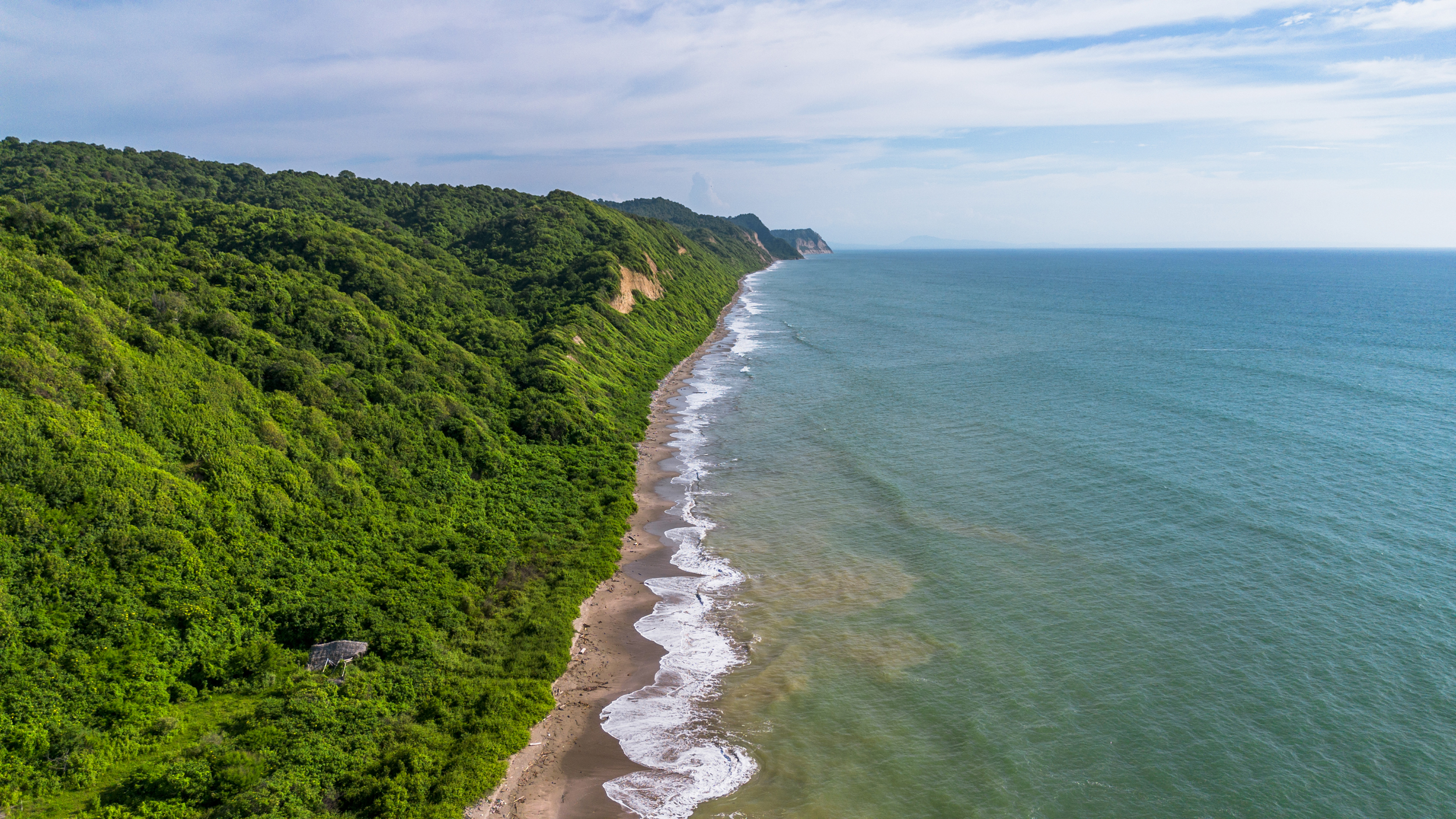
First, conservationists must find a turtle. And unlike the well-known nesting beaches in Mexico and Costa Rica, leatherback nesting in Ecuador is sporadic.
It took 14 people four days of patrolling more than 6 miles of remote coastline—by foot, motorcycle and boat—before the team finally located a nesting turtle they could tag earlier this month. The encounter happened on Pajonal Beach, a rugged stretch of shoreline about 5.5 miles south of Bahia de Caraquez, bordered by steep jungle-covered cliffs and the Pacific Ocean.
Veelenturf had hoped to find the turtle while she was laying her eggs—a stage when sea turtles enter a trance-like state and are largely unresponsive. But by the time the team arrived, the leatherback was already covering her nest.
Working in near darkness, illuminated only by their red-light headlamps, the team moved carefully, timing each of their actions to coincide with the turtle’s natural pauses so as not to disrupt her.
“Every time she stopped and exhaled, I would do a next step,” Veelenturf said.
First, they sanitized a small area of the turtle’s shell where they planned to attach the satellite tag—a small, box-shaped electronic device fitted with an antenna designed to break through the water’s surface each time the turtle comes up to breathe over the next two years.
Then they anchored the tag to the raised ridge of the turtle’s soft carapace by drilling two small holes through it, threading small tubes that serve as fasteners for the device. A quick-setting epoxy was also molded to serve as a secure base for the equipment, helping hold it in place.
Once the tag was attached, the team stepped back and watched as the turtle shuffled its way back toward the ocean.
They called her Lucero, a Spanish word that in English means “morning star.”
“Naming her Lucero is deeply meaningful to us,” said Briones Cedeño. “Just as the morning star guides those who navigate the ocean, this turtle will help guide our understanding of leatherback movements and the future of their conservation in Ecuador and across the East Pacific.”
About This Story
Perhaps you noticed: This story, like all the news we publish, is free to read. That’s because Inside Climate News is a 501c3 nonprofit organization. We do not charge a subscription fee, lock our news behind a paywall, or clutter our website with ads. We make our news on climate and the environment freely available to you and anyone who wants it.
That’s not all. We also share our news for free with scores of other media organizations around the country. Many of them can’t afford to do environmental journalism of their own. We’ve built bureaus from coast to coast to report local stories, collaborate with local newsrooms and co-publish articles so that this vital work is shared as widely as possible.
Two of us launched ICN in 2007. Six years later we earned a Pulitzer Prize for National Reporting, and now we run the oldest and largest dedicated climate newsroom in the nation. We tell the story in all its complexity. We hold polluters accountable. We expose environmental injustice. We debunk misinformation. We scrutinize solutions and inspire action.
Donations from readers like you fund every aspect of what we do. If you don’t already, will you support our ongoing work, our reporting on the biggest crisis facing our planet, and help us reach even more readers in more places?
Please take a moment to make a tax-deductible donation. Every one of them makes a difference.
Thank you,

Teresa Tomassoni
Oceans Correspondent
Teresa Tomassoni is an environmental journalist covering the intersections between oceans, climate change, coastal communities and wildlife for Inside Climate News. Her previous work has appeared in The Washington Post, NPR, NBC Latino and the Smithsonian American Indian Magazine. Teresa holds a master’s degree in Journalism from the Craig Newmark Graduate School of Journalism. She is also a recipient of the Stone & Holt Weeks Social Justice Reporting Fellowship. She has taught journalism for Long Island University and the School of the New York Times. She is an avid scuba diver and spends much of her free time underwater.