

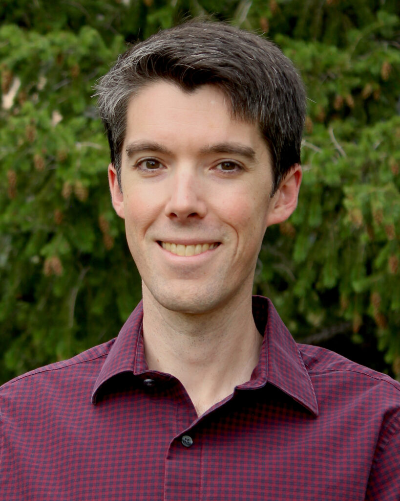
Daniel Swain has made a name for himself studying the extremes of a warming planet. Fires, floods, droughts, heat, storms: if it’s a record breaker, Swain has probably studied it.
As a weather and climate research scientist at UCLA’s Institute of the Environment and Sustainability, Swain has dedicated his life to understanding so-called “outlier events” and how climate change is super-charging them. Then, he explains them, and not just to fellow scientists. He devotes over 1,000 hours a year to climate communication for the public.
Swain is the mind behind “Weather West,” and coined the term “Ridiculously Resilient Ridge” in December 2013, as a first year graduate student, for the high pressure ridge perpetuating the 2011-2017 northern California and Pacific Northwest drought. As a climate scientist, and life long Californian, he has been keeping a close eye on the current El Niño.
Based on a recent study in Science, the current El Niño is likely the strongest in over a millennium. Following this revelation, the U.N. Secretary-General António Guterres warned, “The science leaves no room for doubt: the planet is in uncharted waters, and those waters are heating up.”
Officials from Britain to Los Angeles are issuing advisories for residents to prepare and stock up on essentials in preparation for this historic El Niño.
In a recent interview, Swain and Inside Climate News reporter Nina Dietz discussed why this El Niño is unlike anything we’ve seen before, and what it could mean for California and beyond:
DANIEL SWAIN: So El Niño is a recharge oscillator, which is effectively a battery.
The tropical oceans are a big heat sink. The tropics are warm, there’s a lot of sun directly on the water, and then the currents subduct some of that heat to deeper layers. But then, you reach a point where there’s so much energy in the Pacific that it becomes unstable, and the system needs to equilibrate. The way it does that is through an El Niño.
This is why El Niño and La Niña, the El Niño Southern Oscillation or ENSO collectively, is semi-cyclical, coming around every two-seven years or so. That’s something you can take to the bank. We can view it as a battery, because there is a certain point beyond which it’s not going to continue to overcharge. So El Niño is the ocean system discharging a full battery.
We’re going into extreme territory with this one, probably record breaking. It’s possible we could have another one in a couple years. But it would be pretty hard to have another strong one just a couple years from now because this one looks like it really will discharge the battery. But simultaneously, the battery is getting larger and refilling more quickly with global warming.
So it’s a bigger and bigger battery over time. The vast majority of the energy that’s accumulating in the Earth’s system due to climate change is stored in the oceans. So El Niño is one of the ways that the ocean “burps” out this extra heat.
But all that excess energy in the tropical Pacific Ocean discharges into the atmosphere. Once it enters the atmosphere it moves all around the world as that energy dissipates.
The El Niño energy itself coming out of the oceans into the atmosphere is temporary. So it’s not like we are permanently warming because of El Niño. We will see record breaking global warmth later this year and into 2027.
But the problem is that these releases of heat are getting larger because there’s more heat being stored in the Pacific. And it gets even more complicated.
NINA DIETZ: Complicated is great!
SWAIN: Well, how we measure the strength of an El Niño event has changed. Historically, we literally just drew a box, a rectangular box in the tropical Pacific and measured how much warmer it was than on average.
But there’s several problems with this. First, the average ain’t what it used to be, it’s a moving target.
So to account for that, NOAA has now adopted a new metric of El Niño Southern Oscillation intensity known as the Relative Oceanic Niño Index. A change from the Oceanic Niño Index, so RONI versus ONI.
All of the Earth’s oceans are warmer than they were thirty years ago, but the eastern tropical Pacific matters during El Niño because of how warm it’s relative to the rest of the ocean. RONI is useful for understanding storm track shifts. The differential is what dictates where and how the jet streams shift because those are themselves based on temperature differentials.
If you want to know about winter rainfall in California or drought in Indonesia, then the RONI may be the best metric.
However, there are other climate impacts from El Niño that depend on the absolute number, in which case subtracting out that warming signal can be misleading. For example, as of August 24, the RONI is tied with 1997-1998 as the strongest RONI on record for late August. That’s quite extreme.
Clearly, even if you use the more conservative measure, we’re in rare territory. However, if you use the ONI, we’re already in record shattering territory. It’s so far above anything we’ve previously seen, it doesn’t even fit on the same axis.
DIETZ: Is that why there is suddenly a new chart with an extended Y axis?
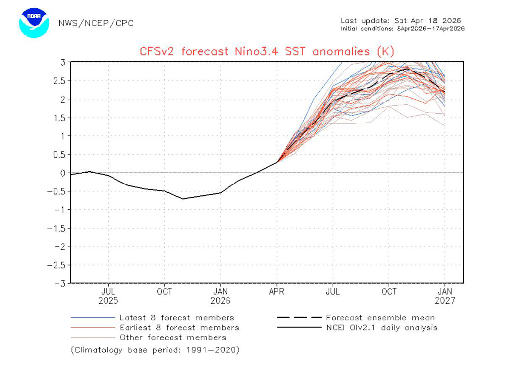
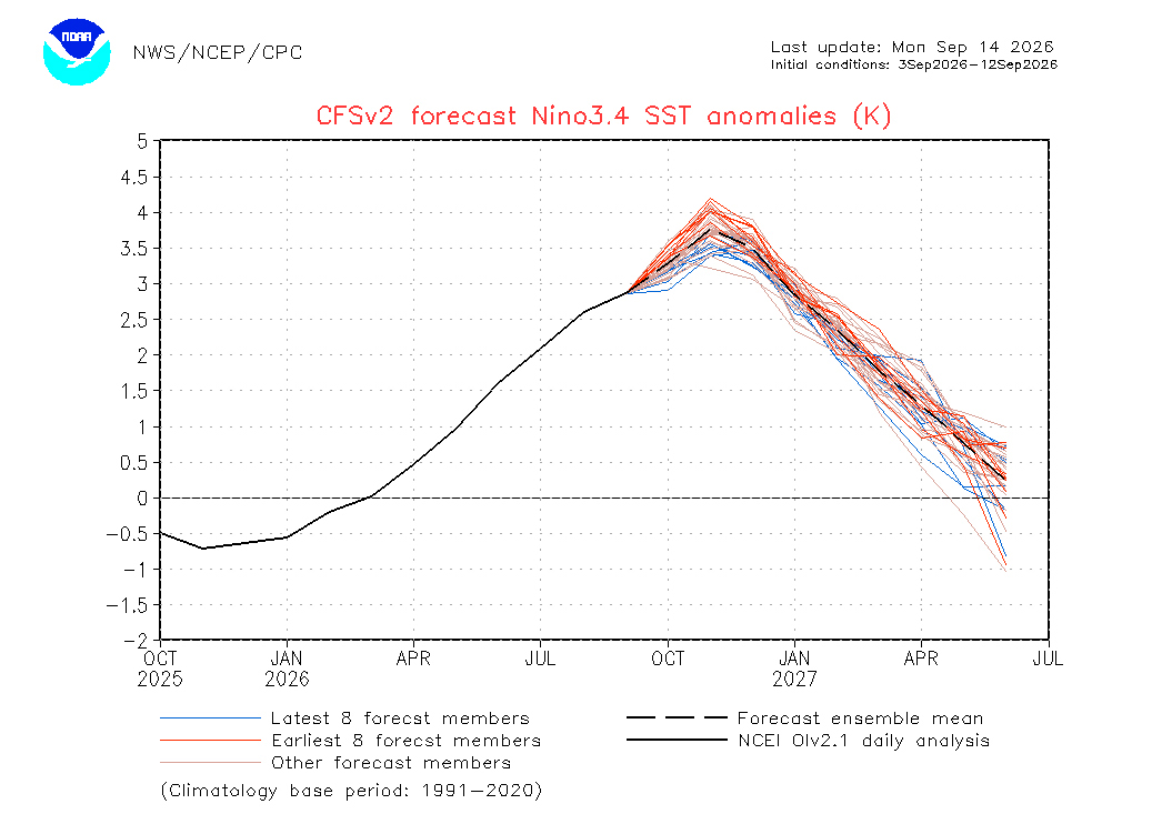
SWAIN: Yeah, so you can get a very different answer depending on which index you use: the RONI, better reflects relative changes which reflect shifts in the storm track. But the absolute changes matter for the overall acceleration of the global hydrologic cycle.
That doesn’t care about the relative gradients in the Pacific. It’s just a function of what is the average global temperature, which is going to scale more with the absolute intensity of ENSO.
If you use that overall climate perspective, you get really a more alarming answer from the absolute numbers because they are telling us that later this year into next year we’re going to, almost certainly at this point, see record-breaking global temperatures again. Breaking even the temperature records we’ve seen in recent years, perhaps by a considerable margin, and also an increase in the intensity of the global hydrologic cycle.
We may see temperatures next year that are close to that 1.7 degree centigrade range, and could even be higher than that.
It’ll give us a taste of what well above 1.5 degrees looks like. That will be next year’s climate in terms of temperature, extreme rain, extreme drought and wildfire. And that’s something we would not fully glean just from this RONI index.
DIETZ: I’ve heard it being called the “Godzilla” El Niño?
SWAIN: Well, this one is shaping up to be monstrous. Though to be clear, that isn’t an actual category. That tops out at “very strong.” We don’t have a categorization for this.
Interestingly and alarmingly, the forecast for this fall suggests that it’s going to strengthen so much more that it will no longer matter which index we use, it will most likely be record breaking by late autumn either way. It’s going to further separate from the pack. This year is going to be tumultuous.
DIETZ: What will this mean for people living through it?
SWAIN: It depends dramatically where you are, because one thing El Niño does is, in some places it results in persistent extreme rainfall and in other places, extreme drought. It really is very regionally specific. What the absolute temperature is telling us is that the overall intensity of those extremes are likely to be larger. The atmosphere behaves akin to a progressively larger kitchen sponge, the warmer it is. It’s purely a function of temperature, believe it or not.
It really just comes down to the fact that the rate of evaporation is exponentially higher at higher temperatures. And what goes up must come down.
DIETZ: What do you worry about for people across California?
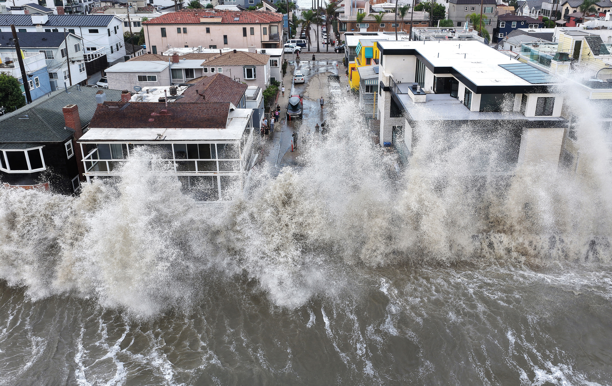
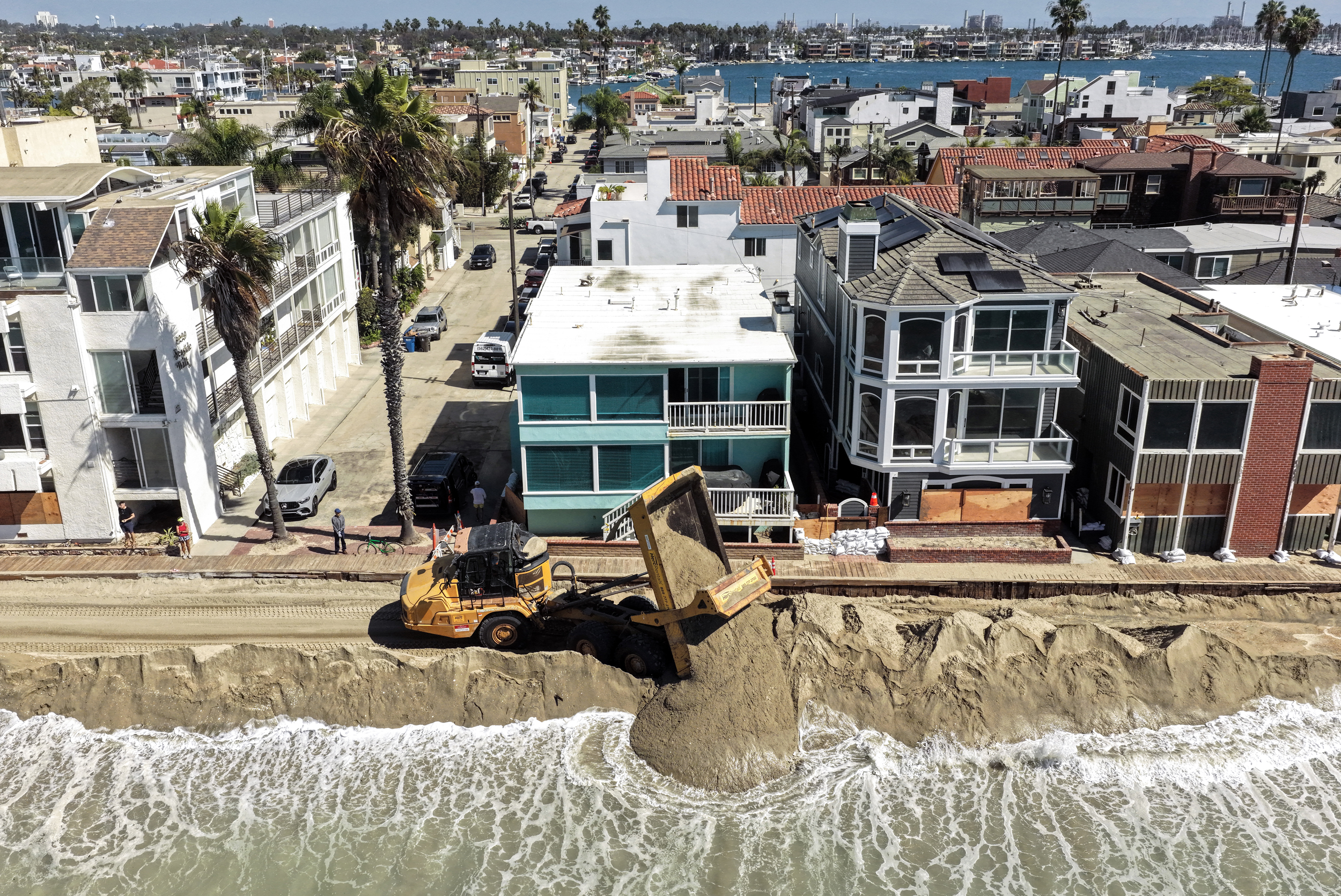
SWAIN: The number one concern I have this winter is for people who live on the coast of California, because this record breaking El Niño will double the amount of sea level rise we’ve seen from climate change overnight.
DIETZ: Wait, really?
SWAIN: We’ve seen about eight to 12 inches of sea level rise due to climate change historically over the past century in California, which has already caused its own problems.This event will probably add another foot on top of that just between now and December.
That’s a pretty big deal because for this winter, sea level rise will temporarily double overnight. And on top of that, El Niño also increases the likelihood of significant winter storms right during the season of highest tides.
So not only do you have temporary elevation of sea level on top of the permanent climate change induced sea level rise, but you also have an increased likelihood of really big ocean waves, and on top of that, temporary storm surges. We don’t get 20-foot storm surges like during a Gulf Coast hurricane, thankfully. But you can still get a foot or two.
DIETZ: That doesn’t sound too bad?
SWAIN: Well, if you add a foot or two on top of a foot of sea level rise, on top of a foot of El Niño temporary rise and then you stack it…yeah. We also have the king tides, which peak right around when all the rest of this peaks in November and December. And this year’s king tides, unfortunately, are going to be among the highest.
This is purely chance, not climate related, but they’re going to be especially high in November and December this year.
This story is funded by readers like you.
Our nonprofit newsroom provides award-winning climate coverage free of charge and advertising. We rely on donations from readers like you to keep going. Please donate now to support our work.
Donate NowSo the likelihood of record breaking coastal flooding in California is pretty high in November and December especially. And remember, in California, the highest risk of coastal flooding isn’t always along the oceanic coast, ironically, but it’s in places like San Francisco Bay.
But this affects millions of people, including people who might not think about it as much because they don’t live by the ocean, but they’re within a few feet of sea level on a tidally connected bay or estuary. That’s the number one issue.
And I mentioned it first because it’s almost certain to happen.
The other piece is the rainfall in California.
DIETZ: Oh?
SWAIN: A wetter-than-average winter in California is extremely likely, and especially in Southern California. But also there are growing odds of a very wet winter that could bring increased freshwater flooding risk. So we have those two things together. That’s a medium high-confidence statement.
The coastal flooding is at this point practically certain. But both of these in some places can combine where you have freshwater outflows and saltwater inflows mingling.
DIETZ: When you’re talking about the sea level impacts, especially with these king tides and adding in a couple storm surges for good measure, what would you want people to understand going into this?
SWAIN: I focus a little more on the coastal impacts because they’re a near certainty. They do not depend on El Niño bringing particularly heavy rainfall. I think it probably will, but that’s still in very probable territory rather than certain. But this sea level elevation is unavoidable with an El Niño of this magnitude. And the impacts will likely be quite large. I mean, think about the impact we saw in ‘82-’83 or ‘97-’98, and then we add the effects of cumulative sea level rise since then.
DIETZ: Can you give some idea of the ‘97-’98 impacts?
SWAIN: In California these resulted in massive coastal erosion. Think California’s Highway One, for example. There were huge landslides taking out highways and transportation corridors.
Just the first few inches of elevation in Southern California have already caused enough erosion to close the Amtrak line along the coast, and this is just the beginning.
In the past, some of the worst flooding was in ocean-facing harbors like Santa Cruz, by waves washing past the typical shoreline. Some of the most disruptive stuff has been places like the interior of San Francisco Bay, where places like Marin County, Napa County and the Palo Alto even experienced major flooding because the bay rose up over the levees and the seawalls and flooded neighborhoods and freeways with significant depth. And just last year, we saw record-breaking coastal flooding without a strong El Niño in some of these places.
There are a number of critical transportation arteries, Highway 1, Highway 101; many of the major Bay Area Airports; most of the big tech firms, Facebook, Google; these are all in places that are susceptible to significant flooding from the bay.
I think some of the greatest impacts from this might be in places like the San Francisco Bay Area, which is not always intuitive, but there’s a huge amount of people and infrastructure within six feet of sea level there.
DEITZ: And is that six feet on top of current sea level, or is that six feet from pre-sea-level-rise?
SWAIN: Oh well, I think either way. To put it into perspective, major interstates and highways in the Bay Area now flood a little almost every king tide. Now the difference is, it’s sort of manageable, arguably, when there’s only a few inches of water on some of these roads, a few times a year and in a predictable cycle. But it’s going to be very different if it’s feet instead of inches and if it’s many times and not always on the same predictable king tide schedule.
Some lower lying areas that would have flooded during king tides normally will be more or less inundated for the winter. But the problem is really going to be the places just above those elevations that would typically not flood during king tides. They might flood this year. And I don’t think people there will be prepared.
The infrastructure is extremely vulnerable at one-to-two feet above typical king tide range. The damage can be devastating. This is a classic example of built thresholds. We’ve built seawalls, we’ve built road elevations, we’ve built structures to the high end of what we’re used to historically. As soon as we start exceeding that with water, it starts to become a significant problem because even a few inches of water in your home is a big problem. And cars and infrastructure and all the stuff that’s exposed to salt water has an even bigger problem than freshwater.
DIETZ: Can you explain why La Niña follows El Niño?
SWAIN: El Niño drains the battery. When you plug it back in, it’s going to take a while for that charge to build back up.
That’s why La Niña is more likely to follow El Niño, but more importantly, following a very strong El Niño, the odds grow that La Niña will follow because we have more completely discharged that battery. Odds are high that a La Niña is likely next year.
DIETZ: So people shouldn’t be banking on the extra precipitation this year to save us from the current water crisis?
SWAIN: In some places, one year buys you a lot. But will this solve the Colorado Basin crisis? The short answer is an emphatic no. But not because it won’t be wet there. Even the wettest year on record wouldn’t solve the Colorado Basin crisis. It’s not just one, two, even three dry years. It’s three dry decades.
There’s the additional issue of there being more demand for water than there ever was in the first place, even before the amount started decreasing. And on top of that, climate change is decreasing the amount that’s available.
This won’t solve anything. It might help in the short term. We might be in slightly better shape next summer if we get lucky.
But it doesn’t offset a decade or two of drought. It offsets this year, maybe. It might put us back to where we were a year or two ago, which was still a crisis in terms of the water scarcity.
It might give people an excuse to stall for another year and not address the underlying issues. Most likely it will just prolong the inevitable march toward deadpool a little longer.
About This Story
Perhaps you noticed: This story, like all the news we publish, is free to read. That’s because Inside Climate News is a 501c3 nonprofit organization. We do not charge a subscription fee, lock our news behind a paywall, or clutter our website with ads. We make our news on climate and the environment freely available to you and anyone who wants it.
That’s not all. We also share our news for free with scores of other media organizations around the country. Many of them can’t afford to do environmental journalism of their own. We’ve built bureaus from coast to coast to report local stories, collaborate with local newsrooms and co-publish articles so that this vital work is shared as widely as possible.
Two of us launched ICN in 2007. Six years later we earned a Pulitzer Prize for National Reporting, and now we run the oldest and largest dedicated climate newsroom in the nation. We tell the story in all its complexity. We hold polluters accountable. We expose environmental injustice. We debunk misinformation. We scrutinize solutions and inspire action.
Donations from readers like you fund every aspect of what we do. If you don’t already, will you support our ongoing work, our reporting on the biggest crisis facing our planet, and help us reach even more readers in more places?
Please take a moment to make a tax-deductible donation. Every one of them makes a difference.
Thank you,