On a clean summer swell, the wave at Malibu’s Surfrider Beach arrives from the south, wraps around a cobblestone point and unspools toward the pier in a long, shimmering wave that can carry a surfer for hundreds of feet. It breaks slowly, forgivingly, over rounded stones that were delivered by Malibu Creek across millennia.
The beach plays an outsized role in American and surf culture, inspiring the films “Gidget” and “The Endless Summer” and the songs of the Beach Boys. The point produced the longboarding style that still bears the place’s name: In Australia, longboards are called “Malibus.”
Kassia Meador has been reading this wave for nearly 30 years. She was 15 the summer she first paddled out at Surfrider Beach, and she has spent the decades since becoming one of the most recognizable longboarders in the world. She calls it, without hesitation, the best wave on the planet.
Lately, when Meador paddles out, something is missing beneath her: the beach. The sand at Surfrider Beach has thinned to the point where, at high tide, the ocean reaches almost to the Pacific Coast Highway. The wave itself has changed shape; the three distinct points that made Malibu’s Surfrider Beach have collapsed into one, she said. “It bunches everybody together,” she said. There’s more crowding and more tension in the water, and less of the wave that made the place worth protecting.
What’s happening at Malibu is about human intervention—a century of dams, seawalls and paved-over rivers that have starved this coastline of the sediment that builds its beaches. But it is becoming a climate story, fast, because a coast stripped of its natural defenses is a coast with nothing left to absorb what’s coming. And what’s coming this winter is a lot.
NOAA’s Climate Prediction Center has an El Niño Advisory in effect and puts the odds of a very strong event this fall and winter at greater than 90 percent—it recently broke the highest surface temperature recorded for this phenomenon, months before the projected peak. California Governor Gavin Newsom declared a statewide emergency on Monday in anticipation of heavy rainfall, high waves and flooding the phenomenon could bring.
Malibu’s First Point is one of 57 surf breaks a team of scientists, working with the conservation group Save the Waves, assessed in a study published this year in the journal Climatic Change. Their finding was blunt: Globally significant surf breaks are vulnerable to climate change, with 89 percent at medium or high risk from the loss of shoreline resilience and 79 percent from sea-level rise. Malibu made the list. But Malibu is only a single, visible instance of a reckoning unfolding along the entire California coast, where the sand that builds beaches has been cut off at nearly every source: trapped behind dams in the rivers that used to deliver it and sealed behind seawalls in the bluffs that used to shed it.
Holding Back the Sand
A beach is less a fixed place than a slow river of sand, fed by creeks and eroding bluffs and carried along the shore by waves. At Malibu, that sand and the cobble beneath it also shape the wave itself. Less sand means a thinner beach and a wave with less to stand on. To understand why the supply has dried up, you have to look inland, to a hundred-year-old dam few Californians have heard of.
Rindge Dam was built across Malibu Creek in 1926 and filled completely with sediment within about three decades—sediment that once washed down the watershed every winter and rebuilt the beach every summer. It cut the creek’s sand delivery to the coast from roughly 41,000 cubic meters a year to about 14,000.
About 780,000 cubic yards of sediment sit behind the dam today, roughly half of it sand suitable for beaches, according to California State Parks.
It is a small piece of a statewide pattern. California’s major coastal dams have trapped an estimated 152 million cubic meters of sand that would otherwise feed the state’s beaches since 1885, according to research by Gary Griggs, a coastal geologist at UC Santa Cruz who has spent five decades documenting the state’s disappearing shoreline. In Southern California, he’s found, the natural sand supply has been cut roughly in half.
Elle Overs, a marine biology Ph.D. student and a longtime Malibu surfer, sees the same mechanism everywhere she looks. “It’s a current problem that stems from a hundred years of sediment being stored up behind the Rindge Dam,” she said, and behind the concrete channels that entomb the Los Angeles and Santa Ana Rivers. “Naturally, those rivers should be bringing dirt and sand to their respective beaches.”
Further complicating the situation in Malibu is California State Parks’ 2013 restoration of the Malibu Lagoon that reconfigured the channels behind the beach to improve water quality. By most accounts, the project succeeded in doing so, but many local surfers, Meador among them, blame the project for wrecking the wave. She argues the lagoon’s mouth was never properly reset afterward, so for more than a decade it has opened toward First Point rather than at the western end of the beach, near Third Point, cutting into the sand.
This story is funded by readers like you.
Our nonprofit newsroom provides award-winning climate coverage free of charge and advertising. We rely on donations from readers like you to keep going. Please donate now to support our work.
Donate NowCalifornia State Parks has no plan to manage the lagoon’s mouth. Its statewide policy is to let lagoons open and close naturally, said Richard Van Sant, the Rindge Dam project manager, because breaching them artificially can flush lagoon species into the ocean and kill them. Van Sant, who joined State Parks after the restoration, said he could not speak to the project itself.
Not everyone in the water agrees. Tom Ford, CEO of The Bay Foundation, which was involved in the restoration, said the wave was already changing before 2013. “Those changes started long before that restoration project,” he said, declining to assign it a single cause, noting that he isn’t a coastal modeler. Overs goes further, pushing back on her own community. “Everyone’s very quick to blame the lagoon and State Parks,” she said. “State Parks is doing the best they can.” The real problem, in her view, is upstream and statewide.
A People Problem
Beaches erode; it’s what they do. The problems come from the ways humans have built around them, and what happens when there’s nowhere left for beaches to retreat.
Or, as Zach Plopper of the Surfrider Foundation puts it, “erosion is a people problem. It’s not a nature problem.”
Charles Lester spent 20 years at the California Coastal Commission, the last five as its executive director, and now directs the Ocean and Coastal Policy Center at UC Santa Barbara. Most of California’s shoreline has been receding for thousands of years, he said, and beaches are simply the buffer that migrates landward as it goes.
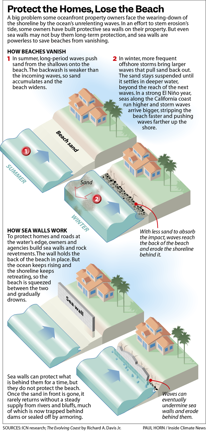
“If you build a seawall, you stop the movement at the back of the beach, and so the ocean’s continuing to rise, but the back of the beach is not moving, and eventually the beach is squeezed out.” Geologists call it passive erosion. “If we want beaches,” Lester said, “we don’t want seawalls generally on our beaches.”
And yet the seawalls keep going up, because as beaches thin and storms—powered by climate change—reach farther, a wall is the quickest way to protect homes and roads already sitting at the water’s edge. Roughly 14 percent of California’s coast was armored as of 2018, up from 2.5 percent in 1971, and nearly 38 percent across the four most developed southern counties.
Lester’s explanation is less about science losing than about law and inheritance. California’s Coastal Act drew a line: Development that already existed when the law took effect can be granted a seawall if it’s in danger, while anything built afterward must be sited so it never needs one.
In Southern California, where the shoreline was largely built out before the law arrived, the grandfathered category is enormous. “It’s been hard to say no in those cases,” Lester said, “because of the way the law was written.”
Now add a record El Niño. El Niño years can raise sea level along the California coast independent of long-term climate change—six to twelve inches, Lester notes, from the added heat and energy in the system—and bring bigger storms on top of it.
“I really think,” Plopper said, “the 2026–2027 winter is going to be the year of reckoning for the Southern California coastline.”
Lester has watched this cycle for five decades, and he’ll tell you how it ends. “It’s a pretty good bet that this time next year we’ll be looking back at a lot of emergency permits that were approved for new rock and new seawalls,” he said.
He isn’t cynical about it; he’s been the person signing those permits. When houses are actively falling into the ocean, an agency approves the emergency armor. But emergency decisions, he said, “usually don’t get you where you want to be in the bigger picture.”
Property values aren’t always part of the legal test, Lester said, but they shape the options, and in Malibu, prices are high. The Commission always asks first whether a building can be moved back, Lester said, which is much easier for a mobile home than for a mansion on a narrow lot. The problem, he said, is an inherited coastline of expensive development “right on the edge in hazardous places.”
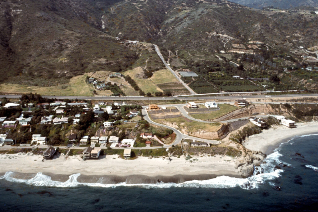
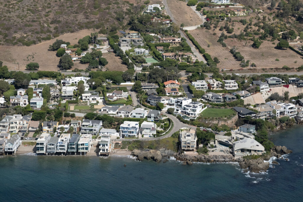
Finding a solution that preserves the wave, the beach and surrounding properties is far from easy.
Australia’s Gold Coast offers one option, and a caution against tidy narratives. Kirra, once a similarly world-famous barreling wave, was an accident of engineering: Training walls extended across the nearby Tweed River in the 1960s starved the coast, and a groyne built at Kirra Point in 1973 to fix that unintentionally sculpted the wave surfers still mourn. Then a sand-bypassing system—pumping roughly the natural transport rate of half a million cubic meters a year across the river mouth—over-supplied the coast and buried Kirra beneath the vast sandbar known as the Superbank.
But Kirra came back. As the excess sand redistributed and managers restored the groyne’s original length, the wave returned, “especially during big swells,” said Griffith University coastal scientist Darrell Strauss, “when many other breaks do not.”
When Cyclone Alfred battered the Gold Coast this year, eroding some four million cubic meters of sand, the city had a plan ready: a buried seawall as last defense, beaches nourished as the first. The southern points came through fine. “Apparently the surfing was fantastic at Kirra during the event,” said Griffith coastal engineer Rodger Tomlinson.
Tomlinson approaches the armoring question from the opposite end of Griggs and Lester: “Seawalls don’t cause erosion, erosion causes seawalls,” he said. The Gold Coast’s answer was not to renounce hard protection but to bury it beneath a beach it commits to maintaining, and to fold surf outcomes into coastal planning—even designing an artificial reef with surfing “front and centre.” California, in Malibu, is still dropping emergency rock and hoping.
Lester is skeptical that naming waves in planning documents is the fix, though he doesn’t dismiss it. The Coastal Commission has protected surfing for decades, he notes, mostly by protecting access; a permit for a mile-long seawall at Santa Cruz’s Pleasure Point carried conditions requiring future impacts to the surf break to be analyzed. Formally designating breaks “could be a good idea,” he said, in the same way naming a wetland raises its profile.
Meador doesn’t want a wall. She wants a plan for the sediment to be released from Rindge Dam over time and the lagoon managed so the beach can rebuild itself. Half of that is on its way, slowly. If funding comes through, the dam will start coming down in 2029, in stages over six to seven years, with about half its sediment trucked to nearby beaches, according to California State Parks.
“Water moves fast,” Meador said, “but it could move fast in the right way, if you do it in the right way.” The surfers who are in the water every day have been asking for that for years, she said, while the people making the decisions “don’t even come down to the beach.”
Lester, from the other side of that table, lands somewhere similar. Planning exists, he said, “to try to get ahead of the things that we want to do a good job of responding to.” This winter will test how much of that California has done.
About This Story
Perhaps you noticed: This story, like all the news we publish, is free to read. That’s because Inside Climate News is a 501c3 nonprofit organization. We do not charge a subscription fee, lock our news behind a paywall, or clutter our website with ads. We make our news on climate and the environment freely available to you and anyone who wants it.
That’s not all. We also share our news for free with scores of other media organizations around the country. Many of them can’t afford to do environmental journalism of their own. We’ve built bureaus from coast to coast to report local stories, collaborate with local newsrooms and co-publish articles so that this vital work is shared as widely as possible.
Two of us launched ICN in 2007. Six years later we earned a Pulitzer Prize for National Reporting, and now we run the oldest and largest dedicated climate newsroom in the nation. We tell the story in all its complexity. We hold polluters accountable. We expose environmental injustice. We debunk misinformation. We scrutinize solutions and inspire action.
Donations from readers like you fund every aspect of what we do. If you don’t already, will you support our ongoing work, our reporting on the biggest crisis facing our planet, and help us reach even more readers in more places?
Please take a moment to make a tax-deductible donation. Every one of them makes a difference.
Thank you,

Kate Waxman
Fellow
Kate Waxman is a Florida-based Outrider fellow at Inside Climate News, where she covers climate injustice across the state. She earned her M.S. in journalism from Columbia Journalism School and her B.A. in environmental science from Barnard, with reporting focused on coral reefs, climate science, and the communities closest to the water.